Wednesday, August 30, 2017

Trail towns, hostels, and grocery stores

Duncannon on the Susquehanna River is one of the towns that divide the Trail into spiritually different sections. The dropout rate among northbound thru hikers typically stops increasing here -- though there will be an uptick when they reach the White Mountains in New Hampshire.

Susquehanna under the overpass
The river crossing here is a customary arrangement when a highway bridge is present. Jersey barriers are set up to isolate a 2-3 foot wide walkway up close and personal with the tractor trailers thundering by.  After spending several days out in the woods, the impact is a little disturbing.

In Maine, however, several creeks will require fording -- as in, take hiking boots off, put on water shoes, and wade across through water that comes from (you guessed it!) melting mountain ice packs. Variety, spice of life, et cetera.


The Doyle - 113 years of hiker legends.
All the sandwiches are made like a hamburger.

The logistics challenge is finding places to refill the five days of food in one's pack without having to go too far off the trail. Common options include trail town grocery stores, resupply boxes sent ahead, or -- shudder -- convenience marts.

Resupply boxes can be sent to general delivery at trail town post offices along the way, to hostels where one plans to stop and clean off a layer of filth,  or can simply be stashed out in the woods near one of the highway trailheads.


Not that AT hikers focus only on food. Dry socks are important, too.

Of course there's ice cream, it's a trail town!

Found my boots and grabbed my hat, on the road in seconds flat

More driving today, a survey run to eyeball some support locations I will need.  That same disorienting feeling as I get driving into southwest Virginia these days -- yes, that ridge, and that one, and it took me about three weeks to cover the distance I am traveling today in a couple of hours.

But when I walk, I don't have to deal with eighteen wheelers, RVs, and Harrisburg's roadway insanities. How can a small metropolis have such a convoluted freeway system?

Here's the mountain ridge intersection where I will need a resupply package.

AT trailhead PA 501


A bit of poesy on the trailhead kiosk. Not an award winner, but true to the attitude.


More photos, next post.


Returned

The Ion pulled up the driveway shortly before 4 pm Saturday.


Total days on road and trail : 54

Total miles: 9500+

Cost: meaningless

Value: beyond price.


Next up, hiking the AT through Pennsylvania!

Saturday, August 26, 2017

A proven answer for centuries, still blowing strong

On an impulse, we added a stop at the Mid Atlantic Windmill Museum to our eastward travels.  Some readers may recall that I stumbled onto this place last year on my westward journey, but found it closed.

Today, it was open!


We toured the property and talked with two of the volunteers that keep these ingenious devices running.

Fascinating designs! Based on European design grain mills that had been built in the Piedmont, settlers found that wind powered water pumps could supplement the few surface water sources available for farming. Railroads also found that windmills could keep trackside water tanks full to replenish locomotives on long stretches between rivers.

Two general concepts were used to make the windmill-driven water pumps automatically point into the wind and control vane speed to avoid tearing themselves apart in high winds.  One popular model (pictured above) used a complex set of hinges that folded back vane segments into a cone shape as the wind speed increased, while also turning into the wind.


A simpler model favored on smaller farms used a fixed wheel of vanes adjusted by a counterweighted paddle that simply turned the vane at an angle to the wind when it was too strong.

In either case, most models required farmers to climb up the towers to grease the gears and replace damaged vanes frequently. Judging by the number of innovative features that builders were adding to simplify these tasks, the maintenance work must not have been very popular.

Many farm equipment suppliers offered windmills.  The museum here is supported and closely tied to Flint and Walling, a leading manufacturer. Here's the steering fin of one of their popular makes, one of the giant ECLIPSE models.


Here's one marked "HUTCH". Hutchinson?


The ridges and plains of this country and of many others are filling up quickly with the children of these great machines.  With good stewardship, they can help solve today's and tomorrow's needs as well.


A tale of two cities

Extra innings today, we stopped in downtown St. Louis to ride up to the top of the Arch, and then crossed the Mississippi to visit the mounds remaining from the City of the Sun, believed to be the largest North American metropolis before the 16th century arrival of of the Europeans.


The Arch is one of the amazing twentieth century creations that resulted from advances in engineering and architectual innovators. Outweighing 7400 elephants and topping any other U.S. monument, the structure is a visionary statement both recalling the fervor of settlers who went into the unknown determined to make their fortune and answer Merriweather Lewis's call and perhaps foretelling other great migrations yet to come.

The visitor area also documents the hard reality of America's dishonorable treatment of the native American tribes displaced by the colonization of the West. Far too much was lost in the haste to justify expansion for power and profit ... yet across the river, there are remains of a city that collapsed before the Europeans arrived.

The story of the great mound city of Cahokia is one of unmanaged growth. Bolstered by the region's bountiful corn crops, the hierarchical society bent its efforts to building elevated dwelling places for the elite. When the city grew beyond the land's ability to support the population, disease and famine brought down the City of the Sun. The common granaries that had stabilized the city's economy when central authority held sway were replaced by family or clan-held stores, the city's population faded away. The largest mound temple in the Americas and one of the most complex astronomical observatories fell into ruin.

The civilization that built the city on the other side of the river might look for some lessons in that.

We spent a while examining Cahokia's Woodhenge, the city's astronomical observatory, and speculating on the designers' approach.  Their use of red cedar sighting poles instead of stones gave them much more design flexibility; holes for several overlapping rings in the same area have been found, indicating that more than one observation grid was built.

Perhaps the relative ease in relocating the poles saved some past astronomer's career when these costly prediction systems failed to correctly predict auspicious events? It's a minor configuration issue, we've fixed it in the newest release ....


One curiosity we managed to resolve in part was the number of poles used to mark out the sighting directions.The builders of the best preserved (most successful?) circle at Cahokia divided the arc into 48 segments.  Why?

Another visitors pointed out that unlike us, Cahokia's astronomers appeared to work more closely with the natural world than the pure numerical shadows.  They had four key data points affecting their crop management planning: the two equinoxes, and the summer and winter solstices. Perhaps one of them recognized that relative to a sight line connecting the spring and fall equinoxes, the sight lines solstices above and below the fall equinox formed equal angles -- in our measurements, almost exactly thirty degrees above and below at Cahokia's latitude.

Setting these poles to match the observed positions of the sun formed the baselines they needed to support agriculture, and repeating that pattern around the circle would give 12 widely spaced poles. Dividing each of these larger segments into four equal parts, Barbara noted, would result in a very practical total of 48 poles.

Since more than one pole circle was built, though, suggests this practical solution was reached by trial and error. We can only imagine the foreman's reaction when the scholars came to him requiring the digging of yet another series of 48 carefully spaced holes deep enough to hold the red cedar poles upright.

Aftermath -- the Oz Winery

The Ion left Nebraska eastward bound, reassured that there would be no more high mountains, high temperatures, and eight hour driving days.

First stop, the Oz Winery in Wamego, Kansas! We enjoyed walking the streets of this small town, and then shopped at the winery for suitable gift wines -- Oil Can and Squished Witch, for example. Sadly, The Lion's Courage, was sold out.  My favorite vintage! Whimper ...

Next stop, Saint Louis!

Aftermath -- a few photos from Eclipse Day 2017


No photos of the eclipse itself -- we were too busy watching! The crowd tended to flow back under the tent during the occasional rain shower, but returned outside as soon as there was any indication that the roiling gray sun shield might thin out.

It did, as described in my last post. Others were equally fortunate! The larger crowd at Carbondale, Illinois, had the same experience of the clouds parting to reveal the black sun. 


New word for the day: umbraphile -- a person obsessed with chasing opportunities to view the totally eclipsed Sun from within the Moon's umbra.

Next opportunity in the continental USA is April 8, 2024. Carbondale is on the path again, but east-central Texas looks like a better weather bet.

There's another total eclipse spanning Chile and Argentina in 2019, though. I could be convinced.


Until then, the Sun is back, the granaries are full, and God's promise not to drown us all is still shining. 

Monday, August 21, 2017

Do not curse darkness. Look for light. [photos follow]


Moods here matched the weather Monday night and this morning. Forecasts for high cloud cover over all of Nebraska not only grew more ominous overnight, but added in warnings of rainstorms. Joy.

Over breakfast, we decided to stay the course rather than rush off on a five hour drivew in search of marginally better forecast weather to the west. A short amble up to the fairgrounds in Beatrice, then.

Good news! The roads were nearly empty, and though the fairgrounds parking area was already filling up and the queue for the shuttle bus stretched across a football field, everything was moving. I set aside concerns raised by reports of jammed highways in Oregon and Idaho, redirecting my thoughts to the thickening gray layer above our heads.

The school bus-turned-shuttle carried us out to Homestead National Monument.

There, we debarked into the crowd. Tents and trucks seĺling shirts, souvenirs, and carnival food made the overfilled park feel like a country fair. Some carnival game booths and a Ferris wheel were all they needed, I thought

A dance performance group tried to overcome a poorly tuned speaker system with children's songs, but eventually yielded to indifference and the usual series of unmemorable speeches by politicians, local community leaders, and proud organizers.

At the NWS tent, the meteorologist was putting her best spin on data predicting a thickening cloud cover and, yes, rain. 

Resigning ourselves to planning to see our first eclipse in 2024, Barbara and I spread out a tarp and lay back to wait until totality arrived. Might as well see what it looks like through the clouds, we decided, so we listened to keynote speaker Bill Nye, talked about going back to the inn and driving on in the morning.

Then the cloud layer pulled back.

Quick! Your glasses! Bill cried. We did ... yes, there, a smooth circular arc blocking part of the sun! The clouds closed in again, and anxious eyes scanned westward for the next break ... the clouds  cloaked and revealed the sun time and again as the dark shadow consumed it. The view lasted long enough for us to watch the last arc  of solar fire start to break up into sparks chasing around the thinning arc of sunlight, clockwise, counterclockwise ... and with the seconds before totality racing away, the clouds closed in again.

The washed-out shades of the sky and of the prairie around us spoke of another world than the one we had greeted at dawn.  Bill Nye and Dr, Amy Mainzer from NASA took turns in a frenzied effort to cheerlead the event, reminding everyone about safety glasses, the historical value of solar eclipses, and about the many strange sights we could see when -- if? -- the clouds pulled back again.

And then they did.
How to explain it? No words I know couldcdescribe that dark disk surrounded by a roiling ring of flame.  Seeing it in person is different; something deep and visceral cried out that this terrible black disk did not belong, that this was a threat somehow.

The sky? Blue, but the darkest twilight shade. There was a planet shining through the haze -- Venus, probably.

Animal sounds or behavior? Lost in the crowd's cheering. A sense of relief?

Two and a half minutes seemed forever, and was over too soon.

Okay, committed umbraphile here. Next US total eclipse cuts through some more meteorologically challenging regions in 2024. God willing, I plan to be there.

Sunday, August 20, 2017

On station and ready!

After a couple of days evaluating Nebraska forecasts on weather and infrastructure and reviewing posted local plans for supporting the oncoming wave of umbraphiles, we have elected to stay with Beatrice and are checked in at our reasonably unreasonably priced motel rooms in Marysville, Kansas.

A sign of future challenges -- the restaurant serving the lodge had only one waitress serving the entire place.  Two employees did not show for their work shift, she said.

Early tomorrow, the Ion will take us to the county fairgrounds parking area in Bee-AT-rice. From there, we will use shuttles to find a good viewing site; the National Homestead Monument shown below is one of those places.

We are ready for the day, daypacks filled with eclipse glasses, sunscreen, snacks, ,some basic first aid, and plenty of water. Yes, and a compass and map.

National Homestead Monument -- NPS photo


Weather forecast for Nebraska is edgy. Nevertheless, as Senator Warren's campaign managers say, we will persist.


Wednesday, August 16, 2017

No Bull [photos follow]

With the storm dwindled into a few scurrying rain clouds, the drive from Rawlins to Fort Laramie took less effort. Still, the hypnotic barrenness of Wyoming's high desert had me looking for a place to pull off the lonely two lane highway for a break -- which gave me the only interesting item to share for the day.

The long stretch of leveled shoulder had a high wire fence separating the road from a partially fenced pasture. Two animals were grazing in it; nope, not cattle, those are bison! And up the road, another cluster of animals, a larger species of deer than I have ever seen.  

A wildlife management study, the sign on the fence said. I will try to retrieve the photos from my camera this week.

The invasive orange barrel species spreading over Wyoming's highways, however, won over my curiosity about Fort Laramie. When the AM radio road bulletins began warning of construction-caused backups between me and Denver, I abandoned my plan to touch another part of the Oregon Trail and turned south.

Tonight's shelter is a hostel in downtown Denver. My fellow umbraphile (aka solar eclipse geek) and I are staying with Europeans who have also come to witness the event; Barbara is in the girl's dorm, and I am in with the guys. 

I enjoy hostels, actually. Less privacy, true, but also much less sterile.


Adventure called on account of Rain

The highway into Wyoming this morning was open and relatively cool under high clouds, running between the red sandstone cliffs in the opposite that the Mormons fleeing religious persecution had taken into Utah.


This turned into an open plains rainstorm with gusting winds just as I went into close quarters with a variety of tractor trailers, pickup trucks, and street racers with California license plates.

Fortunately, I was fortified with a great meal at B J Bull's.  If I could have worked out a way to get those pasties shipped back east ... but, it wouldn't be the same, would it?


When the driver side windshield wiper started to fail, I decided to defer Fort Laramie and end the day in Rawlin.  Tomorrow's plan ends in Denver.

Site admin note: another one of my readers has reported that she tried to comment on one of my posts. Could everyone take a moment to give it a try, and let me know how it turns out for you? If you are not already using a Google gmail account, you may have to sign up for one.  The help files say that any OpenID compliant web service will work, though.  Thanks!

Monday, August 14, 2017

East of Winnemucca

Eastward bound on Interstate 80 -- nothing especially interesting beyond recognizing uninteresting names and landmarks from previous trips. The last of the casinos fell behind as I crossed the final ridge before descending onto the Bonneville salt flats.

Posting photos has turned difficult thanks to a number of equipment problems that will need some attention when I return to Round Hill.

Tomorrow ends in Wyoming, where I hope to visit Fort Laramie of Oregon Trail fame. Bounding across this area at the posted speed limit in air conditioned discomfort leaves me amazed that any of the early settlers survived their westward migration.

Sunday, August 13, 2017

California, motorvated

The family week I enjoyed in California finished up with a day trip to let my grandchildren experience thousand year old redwoods that are taller than the Statue of Liberty. Out of concern for the long drive time and the summer crowds, our hosts chose the "middle size" giants at Big Basin State Forest rather that the bigger ones at Sequoia National Park. Photos follow.

In conversation over an amazing dessert experience with Katie and Brian at a Korean tea house, I praised them for successfully managing life and in high intensity metropolises, and thanked them for sharing some of the exotic enjoyments rarely available outside these places. Korean walnut tea, for example. Who knew?  The same applies for Tess and Will, who have led me to sushiritas, poke, and liquid nitrogen cooled ice cream!

More than enough time wading through Friday rush hour on several freeways as I headed east today. The Ion is pointing East now, looking to cross the Mississippi on or about the 23d and headed for the barn.

The Seal Rock at Morro Bay. Sounded like sea lions, though

Wednesday, August 9, 2017

Reunited again

Monterey, California, always speaks strongly of family to us, though our few memories have been clouded by the years -- or in the case of our younger members, never experienced. Still.


The two grandchildren now share with us the awe of watching a turtle swim above us through a glass plate supporting a multistory column of water, and many of the other unique experiences available in the aquarium that David Packard and his spouse built with his computer industry earnings (yes, he was the Packard of industry giant Hewlett Packard, which started in a one car garage).


Cannery Row has changed almost beyond recognition. The pile of rocks where one of our iconic photos was taken is gone, also. Change is good, but sometimes, as Tom Stoppard observed, sometimes we have to pretend that the smoke from those bridges we burned makes our eyes water.

Friday, August 4, 2017

Footnotes and followups

Some extra items from my journey that escaped posting earlier ...

Here's some photos of the Strawberry wilderness adventure that Kirsten Elowsky offered to share.

Mary, Jakob, Andre, Keith, Michael, Tom -- photographed by Kirsten


More of Kirsten's photos are posted at

https://drive.google.com/open?id=0B5LfK00o3cdgZ0xQTTlTdkVyQzA

I have asked her for some more of the other hikers with us, in addition to all the electronic film she used up on the team's novice. (Viewers are required to provide a Google account.)


A few more photos from the Fold region in Colorado -- the Black Dragon Canyon.


And here's three photos of the Steel Sheep of Grand Junction, Colorado, courtesy Laurie Johnson. For some reason, I thought these might be of interest, if only as a background for some Photoshop artistry?


A quiet day here at the Dunn manse in Castro Valley. All the animals are resting.


Uh, oh

Not yet ... but soon.


Arrived at the Dunn household this evening without any delay or incident.

Wednesday, August 2, 2017

Back on the Loneliest Highway

The Loneliest Highway. Also known as the Pony Express highway, and occasionally as US 50.

Thia morning, rolling west from Ely across the wide valleys toward cardboard cutout mountains on the horizon that become steady uphill grades, sending the trucks over to the right hand lane to huff and puff their way along.  As the day grows warmer, the valleys fill with mirage lakes that flood over the highway ahead, threatening trouble. The lake disappears as it passes by, though, and the highway reappears unharmed.

Pretty cool, really, but getting hotter. Looking forward to the mountains and the forest.

The mechanics in Ely checked the obvious things -- blue smoke from the exhaust on startup, drips from the drain plug. Nothing. I could smell the hot oil burning, I remeinded them, it has to be leaking somewhere ... nope.  Their advice was to keep rolling and check the oil level frequently, thanks for stopping here, no charge, bye!

The advice would almost have been worth what I paid for it, I thought, if it hadn't taken up three hours. Pfft.

I went back to the truck depot to say goodbye to Nathan, and had the good fortune to run into the store supervisor, Nathan's boss, and sing a few bars of praise for my benefactor. Some return for his generosity, at least.

On the way west, I happened on the thriving town of Eureka, Nevada. Photos follow.

At noon, the Ion cleared the last summit before the USFS campground I planned to stay at last night. Beautiful place in Toiyabee National Forest, I will stay there tonight and continue toward Castro Valley. I plan to stop for dinner to avoid rush hour, and arrive mid evening.


Tuesday, August 1, 2017

Delayed


When I checked in, the hotel manager listened to my tale of woe and then cheerily assured me that Ely, Nevada, was indeed at the edge of a Bermuda Triangle for automobiles. The shop where I should take the Ion, she said was Big 8 Tire Auto, and I should ask for Junior. "He's my brother," she confided. "Tell him I sent you."


Somewhat scrambled departure from Grand Junction this morning; I doubled back to retrieve my tablet computer, only to find that Laurie had leaped into her car with it, intending to catch up with me at the service station when I stopped to refuel. All's well that ends well ... tablet retrieved, another opportunity to thank Laurie and say goodbye to Negrita.


I drove to the service station, refueled, adjusted tire pressures, and checked the oil level. It was low again, so I dug out another quart from my stash in the trunk. Joys of owning older cars, &c.


Thirty miles later, welcome to Utah! First warning sign, "EAGLES ON HIGHWAY". Alao falling and fallen rocks, apparently, but all I saw were orange barrels marking the road work in progress. Ah, well, I didn't have much hope that I would be able to clear the salt flats before noon.


Seventy miles into Utah, US 50 started its climb into the geologically fascinating Capitol Reef region of massive seabed sections lifted up on an angle along a hundred mile long fold in the earth's crust. The Ion drive train took the moderately steep climb in stride without dropping below 55 mph, but the air conditioner struggled in its battle with the high-90s heat.


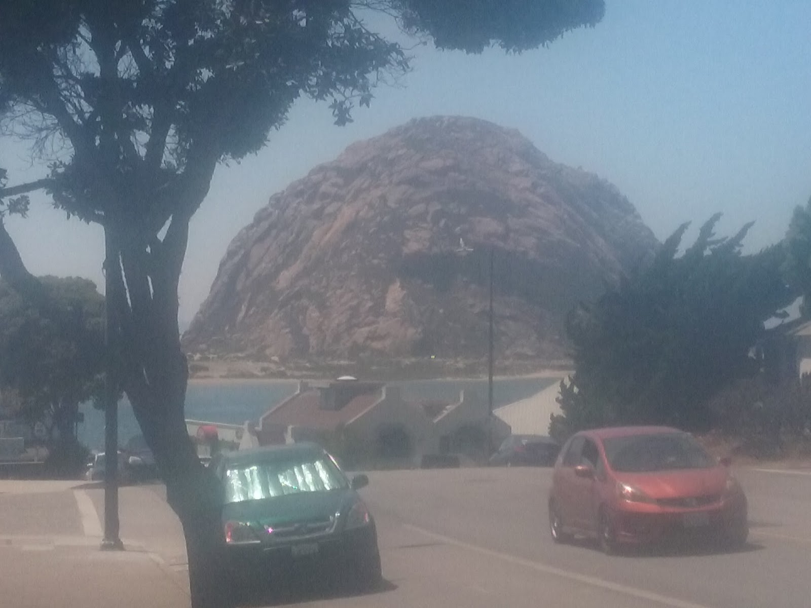
Here's one of the photos I took of the San Rafael Reef during a rest stop; the rest will have to wait untill I have a better uplink. This is definitely a place worth some more wandering -- but not in August.


Descending from 7860 feet to pass Sevier Lake, I continued across the last few miles of Utah's desert, passing by the renowned Salt Flats of car speed racing fame and -- as the car's air conditioner labored -- looking ahead for Nevada's mountain ranges.


Then the low oil alarm went off. Fast stop! Engine temperature still in range, fortunately, but a definite hot oil smell. I stepped out into the early afternoon heat, checked the dipstick. Dry. More oil so I could reach the next service station? No, that was the last one in my stash.


Okay. Emergency cell phone? No, no service.


Right. I put tablet, phone, travel wallet, and a bottle of water into my daypack -- no towel, a crucial omission -- tucked in my shirt, set my straw hat on my head, and hung out my thumb for a ride. Good thing I've been practicing during my AT hikes, yes?


A young couple out on a ramble to Carson City stopped and generously agreed to take me to the next service station to the west. That turned out to be 95 miles and two construction zones away in Ely.


I bought four quarts of oil, and then checked online for a taxi or any other public transit option for the return trip. Nada, nicht, nikto nichevo.


"A taxi from Ely?" the clerk at the register said, and shook his head with a tight smile. "Can't help you there." Another associate, though, heard my request, and suggested that he would be finishing his work shift in a few minutes and would be happy to drive me back. Good fortune! But ... about three hours round trip, I cautioned, and offered reimbursement for his trouble. Nathan waved that away, though he did let me pay for refueling his car.


I made it back to Ely at 7:45 pm. Assuming that this town's name has the same Scriptural origin as Eloy, Arizona's oft-cited desert town of despair, I would say that in ths place and on this day, my God did not forsake me, instead showing once again how many good and generous people there are in the world. Deo gratias.


I plan to post a schedule update tomorrow after Junior has checked out the Ion's oil concerns.